Day 1 - Home - departure
Day 2 - Windhoek - arrival
You will be picked up at the airport and our tour leader or a driver will take you to the hotel in Windhoek. The city is 1680 meters above sea level. If you have some time, you can take a taxi to discover Windhoek. The Independence Memorial Museum in a modern, ugly building built with help from North Korea. At the entrance is a giant statue of former President Sam Nujoma. The museum opened in 2014 and occupies a number of floors. The museum tells about the turbulent history of Namibia, from the German colonization and the domination by South Africa to the struggle for independence and independence in 1990. An impressive journey through the history of the country. From the glass lift and the restaurant on the top floor you have a beautiful view of Windhoek and the surrounding area.
If you want to have dinner in Windhoek, go to Joe's. It is large, busy and touristy (although the locals also eat there), but nevertheless also relaxed, cozy and good. You can eat inside and outside, it is full of old stuff and knickknacks, and there are nice corners everywhere. Is it evening? Have someone from the hotel or restaurant call a taxi, they work with reliable taxi drivers.
Day 3 - Windhoek - Waterberg
After breakfast, after a brief explanation aboutf the motorbikes, we start with today's ride. We follow the highway an excellent asphalt road from Windhoek. After 70 kilometers we pass the old missionary town of Okahandja, a nice place to stop and where there are craft markets. Just to the north of the city is an ostrich and crocodile farm.
In addition to giraffes, gemsboks, roan antelopes, sable antelopes, impalas, klipspringers, leopards and rhinoceroses, the 200 meter high Waterberg Plateau National Park is one of the few places in Namibia that also contains buffaloes. Safaris are organized from the Waterberg Camp or you can hike, which you can also do partly unaccompanied.
Day 4 - Waterberg - Etosha
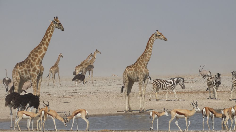
We have to leave on time, it will be a longer ride today. We start on asphalt, but soon that turns into gravel. The white plain and the huge salt pan of 110 by 60 km from the Etosha National Park are unique.
The name Etosha can be translated as 'place of mirrors' or 'place of dry water' or 'the great white place'. When rain falls in the higher rivers, the salt pan fills with a few centimeters of water, which attracts many animals. There are also over forty smaller drinking water places in the park. In the park we can meet the Big Five: lion, leopard, black rhino, elephant and buffalo. One of the attractive sides of a stay in a rest camp in the park is the water drinking area near your bungalow. This watering hole - which is unique - is illuminated at night. Here you often spot wild walking past to the water.
Day 5 - Etosha - stay
Today you can make a game drive with a 4 × 4 car. Traces can form due to periods of rain. There is little high vegetation so it is quite easy to spot animals.
Day 6 - Etosha - Opuwo
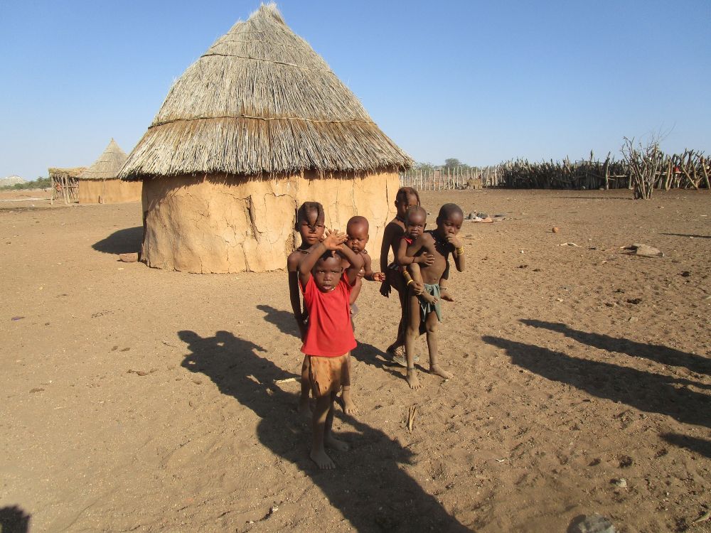
We will leave early again, today is a very long motorcycling day on flat dusty dirt roads. The street scene of Opuwo beautifully reflects the convergence of tradition and modernization. On the street we see traditionally dressed Himbas and Herero women in their 18th century Victorian dresses. Schoolchildren in uniform walk along the road and dress in tight trousers with navel sweaters on Saturday evening. The atmosphere is casual.
Day 7 - Opuwo - stay
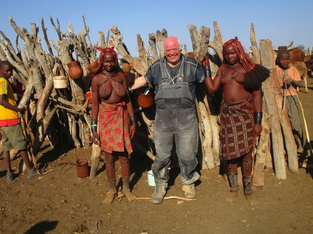
Today we will make a day trip to Kaokoveld or Kaokoland and visit special tribes. The Himba women smeared with red clay are special to see. The way of life of the Himba and Tjimba is very traditional. As a visitor it is extremely important to respect the customs, norms and traditions. Taking unsolicited photos is not polite, nor is walking into a bead unsolicited or stepping between the main cabin and the sacred fire.
The Herero, Himba and Tjimba live side by side peacefully, even though the customs differ. The groups are clearly recognizable. The Herero woman can be recognized by the 18th century Victorian dresses. The Himba and Tjima, on the other hand, live as authentic African nomad tribes. Their lives revolve around cattle and take place in their own corral. The clothing and traditions are still largely intact; time and progress seem to pass these traditions effortlessly. The Himba can be recognized by the red clay on the body and hair. The Tjimba does not use red clay, but uses many more beads as decoration.
Telephone, television, computers are unknown concepts to most Himbas. Although it is often the younger people who are attracted to the modern world, there are still many Himba youth who do not know life outside their bead and have actually never seen a television, even though they may live only 20 kilometers from the 'inhabited' world Opuwo. Opuwo may not be a world city, but modern technology is available with internet, mobile phone and television. It seems almost impossible that the world is so different 20 kilometers from such a village. It is not a question of absent communication: the families know a lot about each other even if they live far apart. The 'bush telephone' functions mainly well.
Day 8 - Opuwo - Purros Village
Another riding day on sandy roads now we head through rugged mountains through the desert towards the famous Skeleton Coast. We take a break in Sesfontein. The name was given by the Afrikaners because of the presence of six fountains. The water ensures that there is significantly more green to see. Sesfontein's biggest surprise is the castle, complete with battlements. The village was built around this fort, which was built in 1896. In those years, the German government established a number of checkpoints where livestock (transport) was checked. There are a number of such checkpoints across the country and collectively they form the so-called Red Line which now marks the boundary between commercial land and traditional land. Commercial land has predominantly commercially oriented farms that want to make a profit from their business. Their land is fenced off. Traditional land is used by local tribes who herd their cattle freely. There are hardly any fences on the traditional grounds. It is another 120 kilometers on sandy roads to Purros where we take a drive through the canyon of the river Hoarisub to find desert elephants.
Day 9 - Purros Village - Palmwag
We leave on time today.
Day 10 - Palmwag - Brandberg
It will be a beautiful day with splendid landscapes. The Brandberg Massif is the highest peak in Namibia: Konigstein at 2573 meters. However, the Brandberg is further north. The mountain takes its name from the fiery glow that can flare up when the sun sets in the late afternoon. Brandberg is best known for the White Lady: a special petroglyph of which some parts are found nowhere else in Namibia. The drawing shows a woman of about 40 centimeters high as the central figure of probably a procession. Some of the figures in the procession have animal features. The woman holds in her right hand a flower or an ostrich egg cup, in her left hand she has an arrow bow. The lady has a white color from her breast.
Researchers from the years' 40s and 50s concluded that there is therefore a link with European paintings; the color is said to have similarities with paintings from Crete. This statement lasted for several decades, mainly under the influence of the Apartheid-tinted line of thought that black cultures would not have been able to be creative themselves. Later researchers see indigenous people in the procession watching the initiation of a black boy or man who has smeared all over clay. It is also possible that the white figure is one especially under the influence of the Apartheid-tinted way of thinking that black cultures would not have been able to be creative themselves. Later researchers see indigenous people in the procession watching the initiation of a black boy or man who has smeared all over clay. It is also possible that the white figure is one especially under the influence of the Apartheid-tinted way of thinking that black cultures would not have been able to be creative themselves. Later researchers see indigenous people in the procession watching the initiation of a black boy or man who has smeared all over clay. It is also possible that the white figure is a shaman.
Day 11 - Brandberg - Walvis Bay
The Atlantic ocean is very cold here. The ride is mainly on sandy roads. Walvis Bay is a lagoon and the natural harbor. Not such a strange name for the bay that is visited annually by migrating whales, especially in October and November. Whalers of various nations regularly went to Walvis Bay to catch their prey. The lagoon, which attracts more than 160,000 birds annually and is a feeding place for another 200,000 migratory birds per year, silts up at high speed due to salinization. Dolphins can be seen all year round. There are usually turtles between November and April. Here you can also take a kayak trip to the lagoon around Pelican Island and to the seal rocks. Walvis Bay is a friendly sprawling village with bungalows that belonged to South Africa until 1994.
Day 12 - Walvis Bay - Sossusvlei
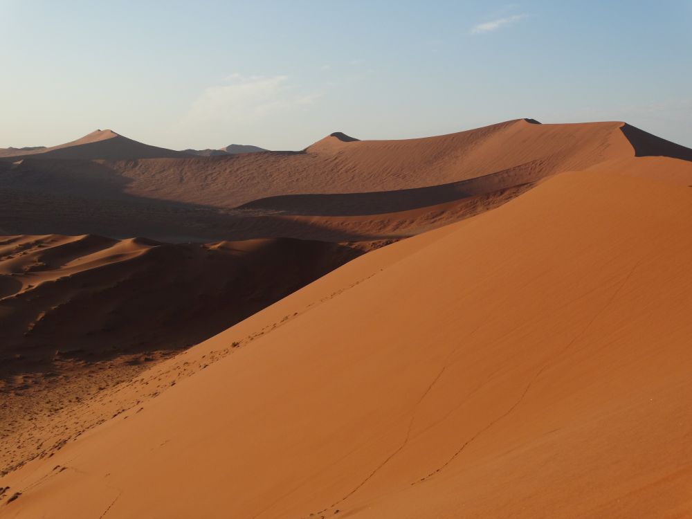
Sossusvlei is part of the Namib Desert in the Namib Naukluft and is the oldest desert in the world. It is said that this desert has had a dry to very dry climate for some 80 million years. The park has an area of 50,000 km2, making it one of the largest national parks in Africa. The word 'flatter' is an African word and means 'more'. The name Sossus comes from the Nama language and means 'place where water meets'. After good rains - and this happens very sporadically - the water of the Tsauchab River collects in the plains and remains there for some time.
Day 13 - Sossusvlei - stay
Today we make a day trip to Sossusvlei. Never forget to bring a hat, sunscreen, and plenty of water. Even on winter days, the temperature can still rise above 35 degrees. On summer days, the temperature rises above 40 degrees. The nights, on the other hand, get very cold and a nasty cutting wind can blow up.
The best thing is not only to view the dune at Sossusvlei, but also to climb it and to look out on the main lake. It is not easy to surface via the sharp sides of Big Mama or Big Daddy. The sand is loose, warm and the sun sets. Once at the top it still feels like an achievement. Also beautiful to see is Deadvlei, a dried up lake with tree stumps that have formed an almost surreal landscape (see below). Dune 45 and Hidden Vlei are another well-known attraction. You will encounter dune 45 on the way from Sesriem to the parking lot and is 45 kilometers away from the entrance. The 86-meter-high dune offers a beautiful view of the extensive dune landscape.
The sand of the dunes consists largely of silicon. The red of the dunes comes from a thin layer of iron oxide. You might expect that the sand in this ancient area was created by erosion and sedimentation, but in fact the sand is brought in from the Kalahari by the east wind. And although the Namib is a real desert, with an evaporation of 1: 300 - an area is called desert with an evaporation of 1: 10 - plant growth is possible due to its location in relation to the cold Atlantic Ocean. The cold water flows drives morning mist into the Namib and ensures that mist penetrates the warm air. The mist can spread over a plain until it is stopped by a mountain range. Sossusvlei itself is located 50 kilometers inland from the ocean, but the dunes are still low enough to allow the cold air to pass and thus still benefit from the sparse mist vapors.
Day 14 - Sossusvlei - Windhoek
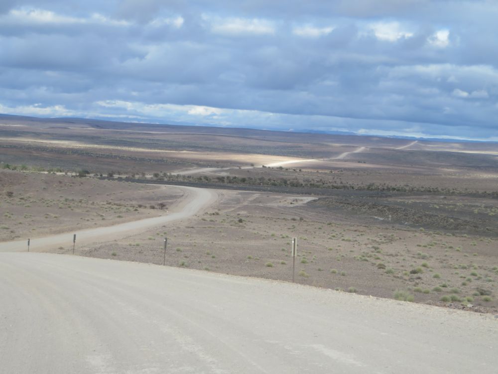
The last day on the motorcycle there is a choice, but the most beautiful route goes along the 2347 meter high Gamsbergpass. This is the Garden Route of Namibia. This Gamsberg has a flat top. The word Gams comes from the Nama and means 'end' or 'closed'. At the top of the pass is a beautiful view of the surrounding region.
Day 15 - Windhoek - departure
Depending on your booked flight, you leave early to the airport or you can explore Windhoek for a while
Day 16 - Home - arrival
-
Tourdetails
Tourcode:NAMCategory:AdventureGroup size:6 - 12Days:16Price:From $3.950,-
-
departures
TourcodeDepartureStatus
-
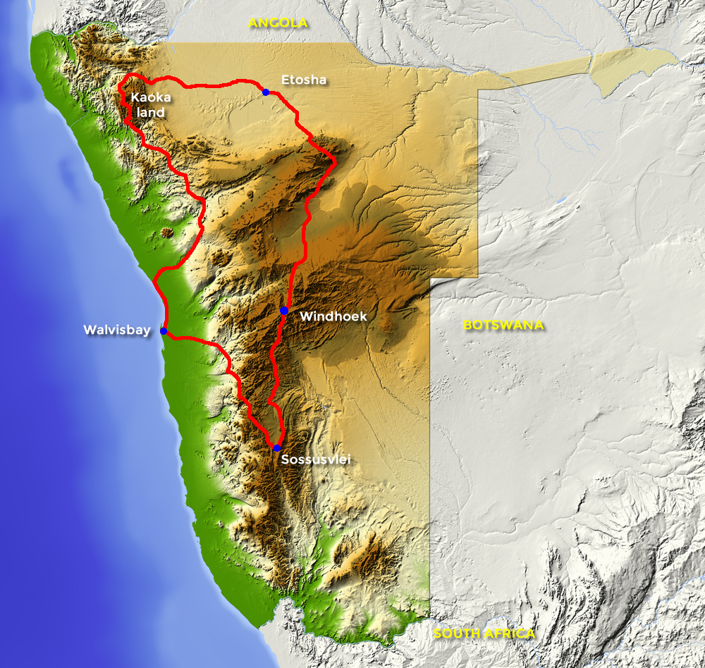
Routemap